


Wednesday, December 30, 2009
City of Norman Emergency Operations Plans
An interesting read. Lists things like City warning siren locations, number of hospital beds available in Norman and the OKC area, and police and fire department structure and org charts.
City of Norman Daily Police Department Activity Logs
The City of Norman has their police daily activity logs on the web as PDFs. Dry reading but I think an excellent example of transparency and openness in government with public records.
Sunday, December 27, 2009
I-35 Aesthetics Design
As part of the I-35 widening project there will be a re-do all of the bridges in Norman over I-35, either as new bridges/intersection or as re-work of existing ones, each bridge having its own theme.
US-77 - Prairie
Tecumseh Road - Tecumseh and the Shawnee
Rock Creek Road - Horses in Motion
Robinson Street - Railroad
Main Street - Land Run of 1889
Lindsey Street - University of Oklahoma
SH-9 E - Lake Thunderbird
SH-9 W - Agriculture and the Chickasaw
The City has a page (http://www.normanok.gov/content/i-35-aesthetics-design) up with a ZIP file (~13.5 meg) containing two PDFs showing the design proposals and an email for anyone who wants to comment on the designs.
There are some really cool designs being considered. Really cool. Worth a read.
Cattle Foraging After The Blizzard

Looking westward at cattle foraging in the field north of W Robinson and west of 48th Ave NW in Norman.
Where Robinson Street Gets Its Name?
I don't know if this is from where Robinson Street in Norman gets its name or not, but an Engineer on the Atchison, Topeka, and Santa Fe RR who worked on the railroad through Oklahoma Territory was named Robinson.
http://skyways.lib.ks.us/genweb/archives/1912/r3/robinson_albert_alonzo.html
This article in The Oklahoman says that's where Robinson Ave in OKC gets its name.
http://blog.newsok.com/archivist/2009/11/05/meet-mr-robinson/
And I'm guessing that's why the theme for the Robinson Street bridge over I-35 is Railroad says this City of Norman newsletter (p. 5, lower right-hand side).
http://www.normanok.gov/sites/default/files/WebFM/Norman/Community%20Resources/Inside%20Norman%20Newsletter.pdf
Saturday, December 26, 2009
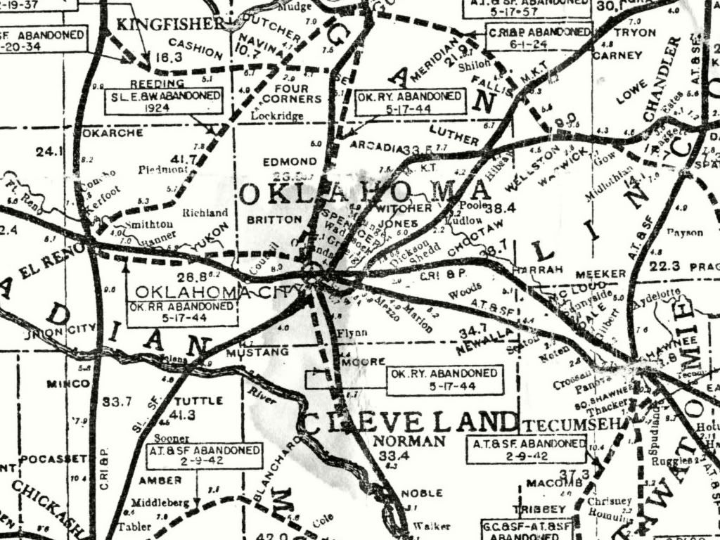
Old Route of the Interurban through Moore to Norman

I found this map on another blog. It lists the route as having been abandoned 5-17-44. Check out Doug Loudenback's blog for lots and lots of great info on OKC history.
By the time this map was made you can see Verbeck had become Moore and Norman's Camp just Norman.
http://dougdawg.blogspot.com/2007/08/okc-trains-part-2.html
Thursday, December 24, 2009

Pics From I-35 and Rock Creek Rd Overpass Area
Here you can see the under construction Rock Creed Rd overpass over I-35 along with all the snow. Visibility is very low.
http://picasaweb.google.com/mwheatley/2009122425OklahomaBlizzard#
http://picasaweb.google.com/mwheatley/2009122425OklahomaBlizzard#


I've Never Been In A Blizzard Before
From the Norman National Weather service office:
URGENT - WINTER WEATHER MESSAGE
NATIONAL WEATHER SERVICE NORMAN OK
937 AM CST THU DEC 24 2009
OKZ018>020-024>031-039>042-045-046-050-242345-
/O.CAN.KOUN.WS.W.0004.000000T0000Z-091225T0400Z/
/O.NEW.KOUN.BZ.W.0002.091224T1537Z-091225T0400Z/
KINGFISHER-LOGAN-PAYNE-CANADIAN-OKLAHOMA-LINCOLN-GRADY-MCCLAIN-
CLEVELAND-POTTAWATOMIE-SEMINOLE-STEPHENS-GARVIN-MURRAY-PONTOTOC-
JEFFERSON-CARTER-LOVE-
INCLUDING THE CITIES OF...KINGFISHER...GUTHRIE...STILLWATER...
YUKON...EL RENO...MUSTANG...OKLAHOMA CITY...CHANDLER...
CHICKASHA...PURCELL...NORMAN...MOORE...SHAWNEE...SEMINOLE...
DUNCAN...PAULS VALLEY...SULPHUR...ADA...WAURIKA...ARDMORE...
MARIETTA
937 AM CST THU DEC 24 2009
...BLIZZARD WARNING IN EFFECT UNTIL 10 PM CST THIS EVENING...
...WINTER STORM WARNING IS CANCELLED...
THE NATIONAL WEATHER SERVICE IN NORMAN HAS ISSUED A BLIZZARD
WARNING...WHICH IS IN EFFECT UNTIL 10 PM CST THIS EVENING. THIS
REPLACES THE WINTER STORM WARNING WHICH IS NO LONGER IN EFFECT.
* TIMING: ALL OF TODAY AND THIS EVENING
* MAIN IMPACT: HEAVY SNOW AND BLOWING SNOW...LOW VISIBILITY AND
STRONG WINDS WITH WIND GUSTS OF 45 TO 55 MPH. BLIZZARD CONDITIONS
AT TIMES. SNOWFALL WILL AVERAGE 4 TO 8 INCHES...BUT SOUTHERN
OKLAHOMA MAY RECEIVE 8 TO 11 INCHES...GENERALLY BETWEEN LAWTON
AND PAULS VALLEY.
* OTHER IMPACTS: A PERIOD OF FREEZING RAIN AND SLEET WILL BE
POSSIBLE ACROSS CENTRAL AND SOUTH CENTRAL OKLAHOMA AS THE
PRECIPITATION TRANSITIONS FROM RAIN TO SNOW. PRECIPITATION WILL
GENERALLY STAY
PRECAUTIONARY/PREPAREDNESS ACTIONS...
A BLIZZARD WARNING MEANS SEVERE WINTER WEATHER CONDITIONS ARE
EXPECTED OR OCCURRING. FALLING AND BLOWING SNOW WITH STRONG WINDS
AND POOR VISIBILITIES ARE LIKELY. THIS WILL LEAD TO WHITEOUT
CONDITIONS...MAKING TRAVEL EXTREMELY DANGEROUS. DO NOT TRAVEL. IF
YOU MUST...HAVE A WINTER SURVIVAL KIT WITH YOU. IF YOU GET
STRANDED...STAY WITH YOUR VEHICLE.
&&
$$


Future Site of Ruby Grant Park, Norman, OK
Norman's looking at developing this park in the future. On their web site at http://www.ci.norman.ok.us/sites/default/files/Parks/PDF_Files/RubyGrantPark.pdf you can see the development concepts for the park so far. It's looking pretty cool.
Wednesday, December 23, 2009


How Norman's Camp became Norman
Also from Wikipedia
"A federal survey of the empty lands along the Arbuckle Trail was undertaken in the early 1870s, headed by 23 year old Abner Norman. Norman’s work crew set up camp at what is today the corner of Classen and Lindsey streets; it was there that the men, perhaps jokingly, carved a sign on an elm tree that read "Norman’s Camp," in honor of their young surveyor.[9] In 1887, when the Topeka and Santa Fe Railroad began service to the area, the railroad continued the use of this name for their station site. The area was opened to settlement as part of the Land Run of April 1889; early settlers decided to keep the name "Norman.""
http://en.wikipedia.org/wiki/Norman,_ok
How Verbeck became Moore
Compliments of Wikipedia
"Moore was founded during the land-run of 1889. The early settlers came on train, horseback, wagons, and some, on foot. According to local historians, the town's original name was "Verbeck" as designated by the railroad company. However, a railroad employee named Al Moore, reported to be either a conductor or a brakeman, lived in a boxcar at the camp and had difficulty receiving his mail. He painted his name - "Moore" - on a board and nailed it on the boxcar. When a postmaster was appointed, he continued to call the settlement Moore. When the town incorporated in 1893 the name was legalized."
http://en.wikipedia.org/wiki/Moore,_Oklahoma
Next stop, Verbeck
"Next stop, Verbeck."
Before statehood, heading north out of Norman's Camp, Oklahoma Territory, Verbeck would be the next station. Norman's Camp is now known as Norman, and Verbeck is known as Moore.
This block is about goings on in Norman, Moore, and northern Cleveland County, Oklahoma in general.
I grew up in Moore and went to university in Norman, where I now reside. So this area and its history interest me.
Subscribe to:
Posts (Atom)